 BGS Data Catalogue
Precipitation (meteorology)
Type of resources
Topics
Keywords
Contact for the resource
Provided by
Years
Formats
Representation types
Update frequencies
Scale
-
Gro for GooD Rainfall Data from 22 Manual Rain Gauges, Kwale County, Kenya (NERC grant NE/M008894/1)
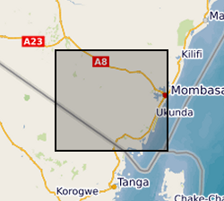
The dataset consist of daily rainfall data for 22 manual rain gauge stations installed by Gro for GooD project within and about the study area. The installed stations covering four river catchments name Ramisi River, Mukurumudzi River, Mtawa River and Mwachema River in Kwale County. The dataset period is from January 2016 to September 2017. Gro for GooD: Groundwater Risk Management for Growth and Development
-
Shrink-swell is recognised as the most significant geohazard across Great Britain. This dataset identifies areas of shrink-swell hazard with increased potential due to changing climatic conditions based on forecasts derived from the UKCP09 research project. The dataset has been created at two levels of detail for different climatic scenarios and dates up to 2080. The Basic dataset is an overview at 2Km grid resolution whilst the more detailed Premium dataset is generated at a 50m resolution. The Open versions are simplified versions of the premium versions and are shared via GeoIndex. The premium versions are paid for products. UKCP09 - UK Climate Projections 2009 project
-
Shrink-swell is recognised as the most significant geohazard across Great Britain. This dataset identifies areas of shrink-swell hazard with increased potential due to changing climatic conditions based on forecasts derived from the UKCP18 climate projections. The dataset has been created at two levels of detail for RCP8.5 emissions scenario and dates up to 2070. The Basic dataset is an overview at 2Km grid resolution whilst the more detailed Premium dataset is generated at a 50m resolution. The Open versions are simplified versions of the premium versions and are shared via BGS GeoIndex. The premium versions are paid for products. UKCP18 - UK Climate Projections 2018 project RCP8.5 - A pathway where greenhouse gas emissions continue to grow unmitigated, leading to a best estimate global average temperature rise of 4.3°C by 2100. Representative Concentration Pathways (RCPs) are a method for capturing those assumptions within a set of scenarios.
-
This is a daily weather dataset that was produced to support hydrological modelling of the Thames catchment including use of the JULES land surface model https://jules.jchmr.org/ . It contains daily values of each of seven weather variables: air pressure, precipitation, wind speed, air temperature, wet bulb temperature, short wave radiation and cloud cover. The dataset was developed from the Met Office Integrated Data Archive System (MIDAS) to enable the calibration of multisite, multivariate weather generators that could be used to provide inputs to JULES using the Rglimclim software package (http://www.homepages.ucl.ac.uk/~ucakarc/work/glimclim.html). The inputs were to be provided both at the station locations, and over a 5x5km2 grid located over the Kennet subcatchment. Topographic and other relevant information is provided for all relevant locations. The weather data contain many missing values: no attempt has been made to restore or interpolate these, since (a) the amount of missing data is so large that any interpolation exercise could have induce substantial biases in the final results of the hydrological modelling (b) Rglimclim does not require complete data records to produce a coherent weather generator.
-
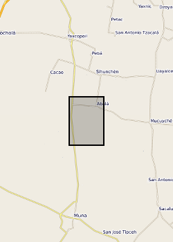
Surface waters and shallow groundwater samples were collected by completely filling 30 mL polyethylene bottles, which were then sealed with electrical tape to minimise the risk of evaporative loss. Rainwater samples were integrated samples of total monthly rainfall collected in a specially-adapted rainfall collector following IAEA protocols (IAEA http://www-naweb.iaea.org/napc/ih/documents/userupdate/sampling.pdf [accessed 22 June 2012). Mexico, State of Yucatan. Yaal Chac (lake) (lake centre is Lat: 20.595274 degrees; Long: -89.711301 degrees), Abala Well (Lat: 20.649044 degrees; Long: -89.679814 degrees) and Xanil ha Cave (Lat: 20.650809 degrees; Long: -89.697426 degrees) Rainwater sampler was located adjacent to the lake. Refer to accompanying map for the precise location of the sampling sites.